Monday, February 28, 2011
Cat skiing at Cloud Cap
The Crag Rats have a new snow cat acquired from Douglas county. It's pretty sweet with a big box on the back and a heater for passenger comfort. Last weekend was the annual Winter Outing and conditions couldn't have been better. Cold, deep snow and plenty of food a beverage were on hand. The ski touring on Cooper Spur Friday was some of the best most of us can remember.
Wednesday, February 23, 2011
Ok, they were right

Tuesday, February 22, 2011
OK, I'm in

The trust level bar is set low but I'm going up the hill in the morning. A 12ish" new and that temp is worthy reason to blow off the few errands and obligations. Let's hope they are right.
Snowboarder pick-off on Mt. Hood
A "pick-off", in search and rescue parlance, is the rescue of a victim from above. It could be a rescuer repelling down a cliff or slope and raising or lowering them to safety or a helicopter lowering a rescuer on a winch cable. In the case of the lost snowboarder yesterday on Mt. Hood, it was an Army Black hawk or Pave hawk helicopter (a Black hawk without the under armor which is lighter) that pulled him from Zigzag canyon on Mt. Hood's south side. Here is the KGW video shot from their chopper. The Virginia resident had hiked to the Hogsback, at around the 10,500' level, and planned to descend back to Timberline. A great run on a clear day or a stormy day with a GPS or compass. But the Mt. Hood Triangle is there to get you if the fall line is all you have for orientation.

What is the Mt. Hood Triangle? Here is a good explanation from Portland Moutain Rescues site:
Most search and rescue operations on Mt. Hood are the
result of climbers becoming lost on their descent from the
South Side Route. Others have become lost while
descending from camps at Illumination Saddle.
The most common problem occurs when visibility becomes
poor and climbers descend without the aid of map and
compass, thinking that if they simply go back downhill,
they will surely return to the Lodge.
However, the fall line (route a ball will take if allowed to
roll down a slope) from the base of Crater Rock to about
the elevation of the top of the Palmer Ski Lift, does not fall
toward Timberline Lodge to the south, but rather
southwesterly in the direction of Zig Zag canyon and the
cliffs of Mississippi Head.
An area of the descent that has caused a number of
people to become confused and lost is the traverse
around the east slopes of the base of Crater Rock, that
area between Crater Rock and the Devil's Kitchen (the
Devil's Kitchen is an area of rock kept bare of snow by
the thermal activity of the mountain.) Occasionally, a
climber will drop too low on the traverse and descend
into the White River glacier and canyon to the east of the
route.
More often, climbers will traverse around Crater Rock,
staying on the correct descent route, but then glissade
down the fall line to the west, unaware they are in trouble
until they reach the canyons or cliffs below.
Carry a map, compass and an altimeter. Use your
compass and believe it! Once you have descended
around Crater Rock, by simply following the direction of
the south end of the magnetic compass needle (i.e.
magnetic due south), you will descend very close to the
ski lifts and Silcox Hut. In low visibility, the descent by
your compass may seem strange in that you will find
yourself side hilling considerably to the left as you
descend from Crater Rock to below 9000'.
When I was descending from Crater Rock in "milk bottle" conditions, in the days before the GPS or cell phones, I would keep my compass bearing around 170 (True North) and go till I almost ran into the lift towers of the Palmer chair. If I drifted more towards a 200 bearing, the Triangle was sucking me towards Zigzag canyon. The Mile chair is oriented at almost a perfect True North bearing, btw.
Here are some GPS coordinates of landmarks for the modern mountaineer:

Saturday, February 12, 2011
Stop the brutal grooming

Wednesday, February 2, 2011
Nea-Kah-Nie, Oregon - One Hundred Years Later

 |
| Looking south from Nea-Kah-Nie mountain towards Manzanita |
With the temperatures in the upper 60's at the Oregon coast and no new snow on Mt. Hood, I decided to take a friend up on his offer to go to Manzanita last weekend. My great-grandfather, Dr. William Skene, use to pack up the family in the summer and head to Nea-Kah-Nie Tavern, in what is now Manzanita, to beat the Portland heat. I think these photos were taken around 1910-12. The tavern is long gone but we played golf at the local 9-holer, threw the Frisbee and ate crab. I like the the old school spelling from the postcards/snapshots, as opposed to the modern Neahkahnie.

 |
| Looking north on Neahkahnie Beach towards Neahkahnie mountain |
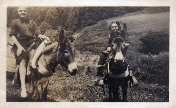
Since the road around Nea-Kah-Nie mountain hadn't been built in 1910, my grandmother Jean and great uncle Don, took mules on the old trail around the mountain, 10 miles or so, to Cannon Beach for lunch. Not a trail for a squirrelly mule. As you can see from the photo below, it was (and still is) a long way down to the cold Pacific water.

Subscribe to:
Comments (Atom)